


I nostri geotrail trasmettono in modo vivido 450 milioni di anni di storia della Terra in tre lingue (tedesco, italiano, inglese). Dall'estate 2019 sono disponibili tre nuovi geotrail: Kötschach-Mauthen, Wolayer See e Lanzenpass-Findenig. I dettagli sui geotrail nel loro complesso sono riportati di seguito.
Attenzione: il geotrail del Laas non è accessibile in alcuni tratti a causa dei danni provocati dalla tempesta. L'accesso agli alberi pietrificati e l'accesso al Pittersberg da sud sono chiusi.
Our geotrails vividly convey 450 million years of the Earth's history in three languages (German, Italian, English). Three new geotrails have been available since summer 2019: Kötschach-Mauthen, Wolayer See and Lanzenpass-Findenig. Details on the geotrails as a whole can be found below.
Attention: The Laas Geotrail is not accessible in sections due to storm damage. The access to the petrified trees and the access to the Pittersberg from the south is closed.
Un'App Geotrail (tedesco, italiano, inglese) è disponibile per il download gratuito su:
the Geotrail app is available under the following link:
IOS:
https://apps.apple.com/de/app/geotrac-geotrails/id1469056717?ign-mpt=uo%3D4
Android:
https://play.google.com/store/apps/details?id=com.divulgando.geotrac
LA GUIDA INTERATTIVA DELLA REGIONE vi permette di pianificare facilmente il vostro prossimo geotrail e molte altre escursioni.
THE INTERACTIVE TOUR GUIDE OF THE REGION lets you easily plan your next geotrail as well as many other hikes.
È possibile scaricare la nostra cartella sui geotrail qui.
Informazioni complete sui geotrail nella parte italiana del Geoparco sono disponibili anche qui.
You can download our folder on the geotrails here.
Comprehensive information on geotrails in the Italian part of the Geopark can also be found here.
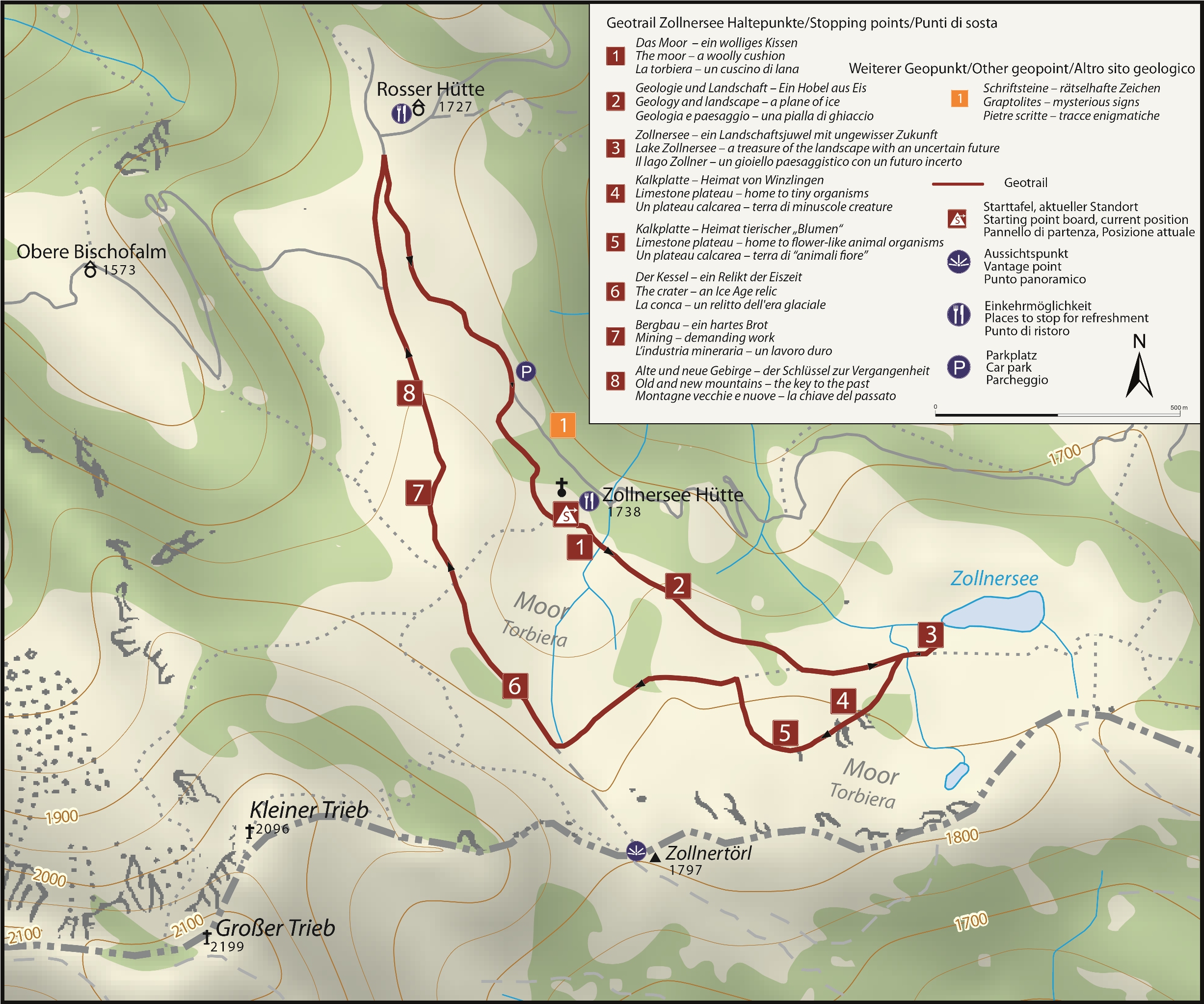
Esplorate il segreto di un paesaggio unico e vario. L'idilliaco lago Zollnersee, le tranquille brughiere, le dolci colline e le aspre cime delle montagne raccontano la loro storia.
Punto di partenza: rifugio Zollnersee
Difficoltà: facile
Lunghezza: circa 4,3 km (totale)
Dislivello: 170 m (salita e discesa)
Durata: 2,5 ore
Altre informazioni: Pannelli informativi sul terreno, gioco di puzzle, lucchetti per i sentieri.
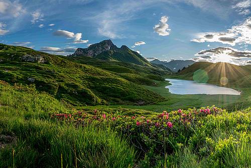
The wonderful alpine landscape to the south of the Zollner Höhe is a paradise for pleasure hikers and families. Easy paths and tracks invite young and old to spend an unforgettable day up here. Lots of small streams and gentle alpine meadows provide plenty of space for children to discover things and let off steam. A trip to the Zollnertörl, where magnificent views of the Italian mountains open up, is not to be missed.
starting point: Zollnersee Hütte l difficulty: easy l lenght: approx. 4.4 km l vertical meters: 210 m l duration: 2.5 h
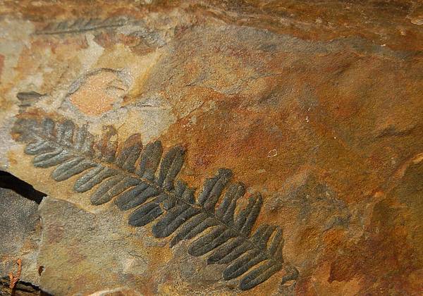
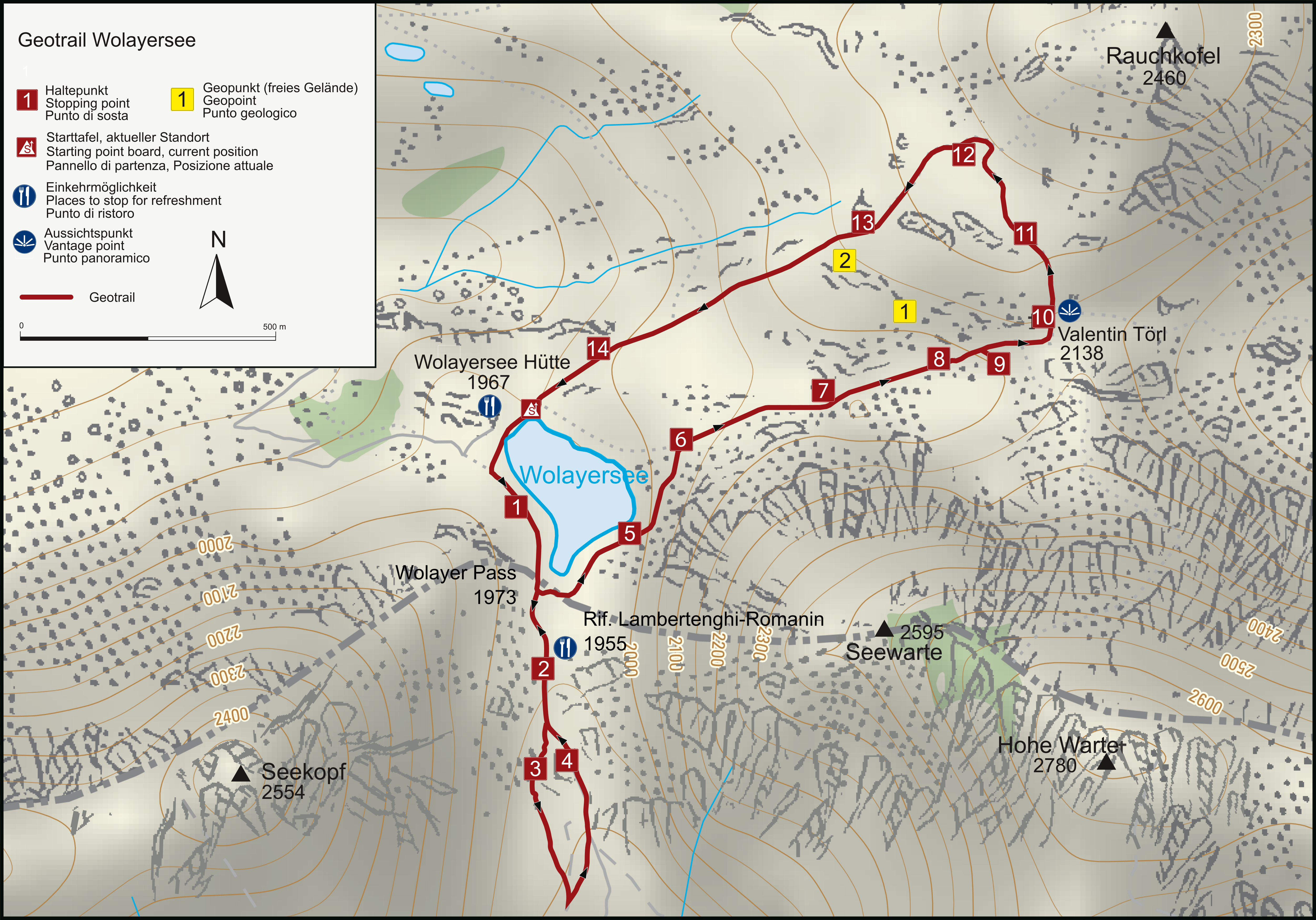
Nel lago Wolayer, di colore blu intenso, si cammina in un mondo marino fossile con coralli, crinoidi e polpi risalenti alla preistoria. Grazie alle sue rocce e ai suoi fossili, l'area è uno dei 100 siti geologici più importanti del mondo.
Punto di partenza: Rifugio Wolayersee
Difficoltà: da media a difficile
Lunghezza: circa 4 km (totale)
Dislivello: circa 700 m (salita e discesa)
Durata: circa 3,5 ore
Ulteriori informazioni: disponibile come app, bacheche informative nella zona sul versante austriaco; Attenzione: la salita di circa 3 ore al punto di partenza del geotrail rende l'escursione un'escursione di un giorno faticosa; si consiglia il pernottamento al rifugio Wolayer See.
Descrizione dei punti di sosta
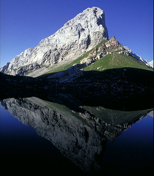
Along the “Lake Wolayer” Geotrail you will discover the remains of an ancient ocean and its fossilised inhabitants such as corals, sea lilies and squids dating back several hundred million years. Because of this juxtaposition of sediment of shallow and deep seas, the Lake Wolayer area is among the 100 geologically most important regions of the world.
starting point: Wolayersee Hütte
difficulty: moderate to difficult
lenght: approx. 4.8 km
vertical meters: approx. 480m
duration: approx. 3.5 h
further information:The “Lake Wolayer” Geotrail itself takes 3 hours, but the long ascent of another three hours to the starting point at the Wolayersee Hütte lodge makes this geotrail a demanding day tour. We suggest planning a two days-hiking tour. For the most part, the geotrail itself follows the much-used hiking paths no. 438 and 403; they require surefootedness but do not run across precipitous terrain.
Le Alpi Carniche tra il Cason di Lanza (I) e la Findenig (Ö) offrono i panorami più belli e sono famose per i fossili di 300 milioni di anni fa del mare di allora e della costa adiacente. Tra questi, i più impressionanti sono le piante fossili finemente conservate.
Punto di partenza: Lodintörl (Ö) o Casera Cason di Lanza (I)
Difficoltà: media
Lunghezza: circa 11 km (in una direzione)
Dislivello: circa 450 m
Durata: circa 6 ore
Ulteriori informazioni: disponibile come app, soste panoramiche in attuazione; se il Geotrail non viene effettuato nell'ambito di un'escursione sull'Alta Via Carnica, è possibile pernottare presso il rifugio Straniger o Zollner Alm o presso il Rifugio Casera Cason di Lanza.
Guida interattiva l Descrizione dei punti di sosta l Mappa Geotrail Lanzenpass-Findenig
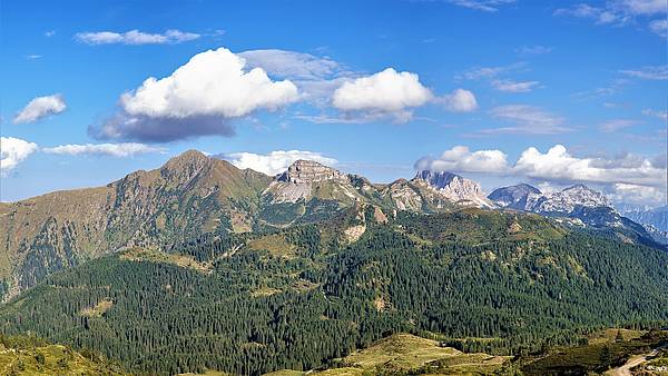
In the Carnic Alps area, between Cason di Lanza in Italy and Monte Lodin (Findenig) in Austria, rocks emerge that mainly date back to a time between the Devonian and the Permian ages, and document a period of about 150 million years, almost without interruption. Not all periods are recorded in the same way but there is a rich documetntation of fossil plants as well as bivalves, brachiopods, and also large amphibians’ footprints.
starting point: Lodintörl (Ö) or Casera Cason di Lanza (I)
difficulty: moderate
lenght: 11.4 km (one direction)
vertical meters: approx. 900 m
duration: approx. 6 h
further information: the travelling times refer to arrival from the opposite end of the itinerary and do not include the return leg of the journey. It is advisable to evaluate staying overnight at Straniger Alm, or dividing the route into two distinct excursions.
hike-tourenguide l description l map Geotrail Lanzenpass-Findenig
Attenzione: a causa dei danni provocati dalla tempesta, alcuni tratti del Laas Geotrail non sono accessibili o sono di difficile accesso. L'accesso agli alberi pietrificati e l'accesso da sud al Pittersberg sono chiusi.
Il Geotrail Laas conduce all'unica foresta pietrificata dell'Austria. Lungo il sentiero geoculturale e nel villaggio, grandi e piccini possono vedere, grazie a molti tesori, quanto la geologia determini la nostra vita quotidiana.
Punto di partenza: chiesa di Laas
Difficoltà: facile
Lunghezza: circa 5 km (totale)
Dislivello: 250 m (salita e discesa)
Durata: circa 2,5 ore
Altre informazioni: Pannelli informativi sul terreno, gioco del puzzle.
Mappa Geotrail Laas l Descrizione dei punti di sosta
Attention!: Due to storm damage, sections of the Laas Geotrail are not accessible or difficult to access. The access to the petrified trees and the access from the south to the Pittersberg are closed.
Ancient fossil trees and the force of water characterize this Geotrail. The petrified tree in Laas is the largest fossilised plant to be found in Austria. As well as good soil, water is essential to the existence of a village. Laas has this in abundance. On the one hand, this is due to its climate, as the Gailtal valley is one of the regions of Carinthia with the highest levels of precipitation. However, the fact that there is spring water of the highest quality here is down to the local geology.
starting point: village fountain at the church l difficulty: easy l lenght: approx. 5.3 km
vertical meters: 250 m l duration: approx. 2.5 h
description l map Geotrail Laas
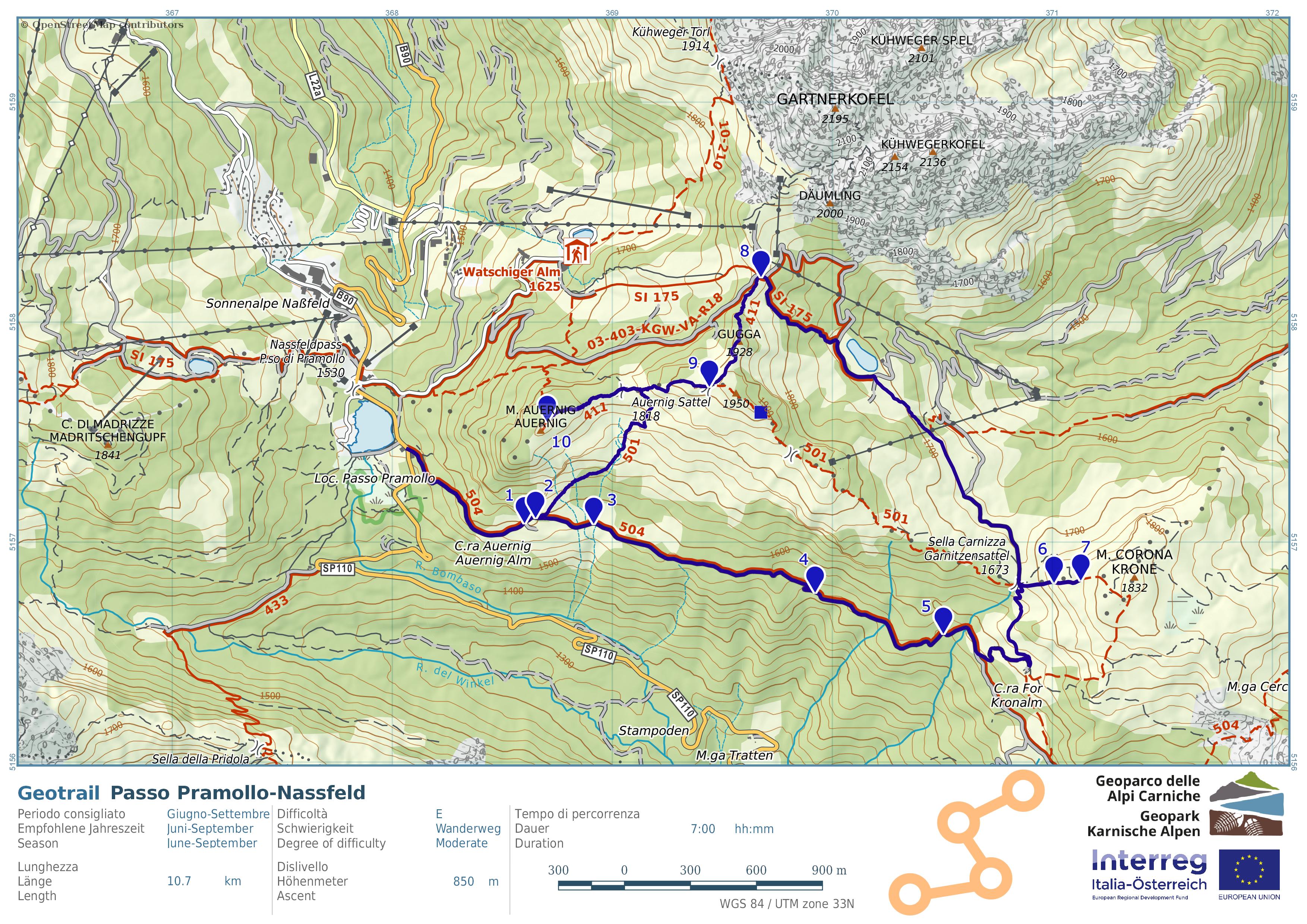
In questo paradiso escursionistico per grandi e piccini, incontrerete fossili animali e vegetali, unici in Europa.
Punto di partenza: Hotel "Al Gallo Forcello
Difficoltà: media
Lunghezza: circa 11 km (totale)
Dislivello: 870 m (salita e discesa)
Durata: circa 6 ore
Ulteriori informazioni: disponibile come app
Descrizione dei punti di sosta
Mappa Geotrail Nassfeld
The Pramollo-Nassfeld cross-border Geotrail located between the Italian and Austrian border, is internationally known for its sedimentary rocks rich in marine and continental fossils. They testify to the changes that took place in this area, which was cyclically turned from a marine to a coastal environment and then to a deltaic one.
starting point: Hotel "Al Gallo Forcello" l difficulty: moderate l lenght: approx. 11 km l vertical meters: 870 m l duration: approx. 6 h
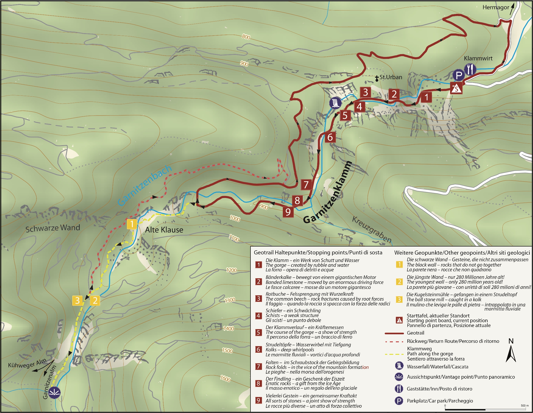
Nella gola di Garnitzenklamm si cammina lungo il rinfrescante torrente Garnitzenbach, costeggiando affascinanti e colorate formazioni rocciose e scogliere, create dalle gigantesche forze della natura.
Punto di partenza: ingresso della gola
Difficoltà: media
Lunghezza: circa 6,6 km (totale)
Dislivello: 630 m (salita e discesa)
Durata: circa 4,5 ore
Ulteriori informazioni: disponibile come app, pannelli informativi nella zona, gioco di enigmistica, lucchetti per i sentieri
Descrizione dei punti di sosta
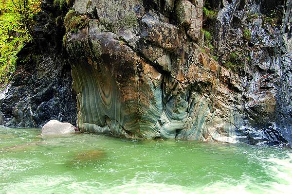
Breathtaking views can be enjoyed all along the route, accompanied by the thunderous waters of the Garnitzen brook. The water has cut its way deep down into the rock, creating a polished surface and offering fascinating views of the inside of the mountains and rocks.
However, the water was not the only medium responsible for this effect. Many different forces contributed to the development of this gorge and its landscape. The Geotrail Garnitzenklamm Gorge explains the forces at work here and how the rocks have shaped the gorge.
starting point: gorge entrance l difficulty: moderate l lenght: approx. 6.6 km
vertical meters: approx. 380 m l duration: approx. 4.5 h
hike-tourenguide l description l map Geotrail Garnitzenklamm gorge
A Kötschach-Mauthen sono state trovate molte pietre fossili straordinarie. Queste possono essere ammirate tra il Gailtaler Dom di Kötschach e l'Hammerle di Mauthen. Le pietre fossili sono integrate da beni culturali in pietra, come l'antica gogna o il colossale "sottopancia" di Mauthen.
Punto di partenza: Gailtaler Dom (piazza principale di Kötschach)
Difficoltà: facile
Lunghezza: circa 2,5 km (una direzione senza deviazioni)
Lunghezza delle deviazioni in direzione Hammerle o Alpencamp: ciascuna di circa 1 km
Dislivello: valle pianeggiante
Durata: circa 1 ora (una direzione senza deviazioni)
Ulteriori informazioni: Pannelli informativi sul terreno, cartella di accompagnamento con le descrizioni di tutte le pietre.
Kötschach-Mauthen is one of the geological hotspots in GeoPark Carnic Alps. In the course of several decades unusual and often massive fossil rocks have been found- frequently by amateurs. These are presented along the lenght of the walk. There are also several stone monuments to be seen- witnesses of human habitation and activities since Roman times.
starting point: Gailtaler Dom (main square Kötschach)
difficulty: easy
lenght: approx. 2.5 km (one direction without side trip)
side trip to Alpencamp/Hammerle - lenght: approx. 1 km
elevation: flat valley
duration: approx. 1 h (one direction without side trip)